On September 17, 1910, Seattle Boy Scouts hiked from the Central District to Fauntleroy. It was just a week after their first hike. Taking a similar walk today covers 13 miles of river, saltwater beach, woods, business districts, industrial areas, railroads, bridges, and transit terminals.
Intro
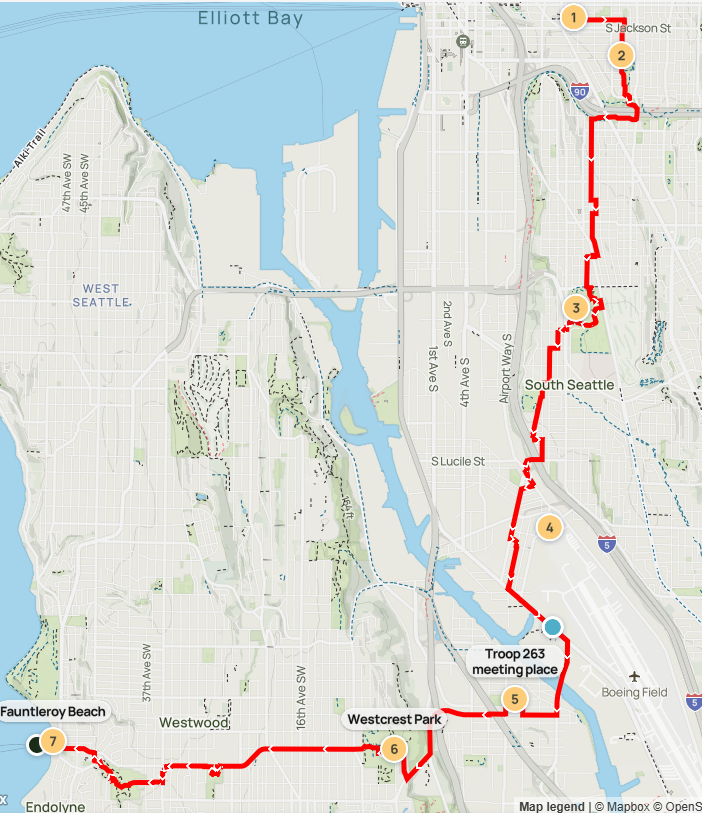
In April 2025, my son and I took a modern version of the second long distance Scout hike in Seattle history. We walked from Seattle’s Central District, over Beacon Hill to Georgetown, across the Duwamish River to South Park, and up and over West Seattle to Fauntleroy. We capped it with ferry rides to Vashon and downtown Seattle, then a bus ride home.
You’re here to learn about the 1910 route, right? Let’s get through those details and then I’ll share my experience. You can choose to retrace the original, mine, or make up your own version.
The 1910 route
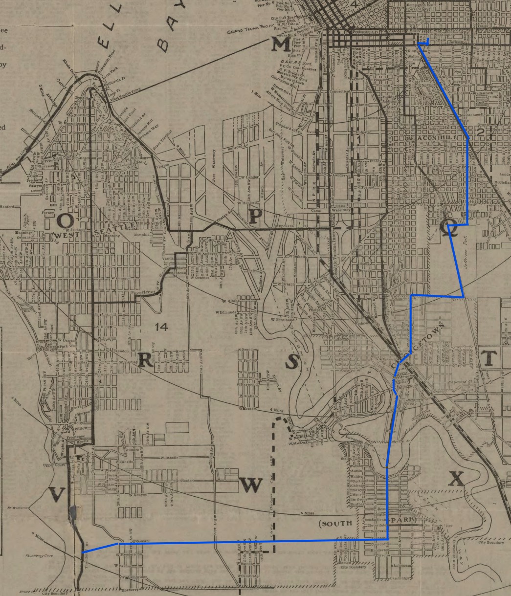
Here’s the route of the original hike on September 17, 1910, explained with modern names and landmarks:
- Start at Wisteria Park at 15th and Washington
- Walk via up the east side of Beacon Hill to Jefferson Park
- Head down the west side of the hill to Georgetown
- Cross the Duwamish to South Park
- Trek up and over the south end of West Seattle to Fauntleroy
The announcement
The Seattle Times pitched the trip in a three paragraph article.
“Boy Scouts to Join in Ten-Mile Trip
“Leaving the Collins playground Saturday morning [September 17, 1910] at 9 o’clock, twelve patrols of the American Boy Scouts, from three of the city’s public playgrounds, will tramp ten miles to Fauntleroy Park on the second of their Saturday outings. J. H. Stine, director of playgrounds, who had charge of the first expedition last week, again will accompany the patrol. Besides the Collins, the Rogers and the Ballard playgrounds will be represented.
“The line of march will be as follows: From Collins playground, Fifteenth Avenue and Washington Street, south over Beacon Hill, past reservoir and stockade, southwest to South Park, thence due west through thicket and brush to the Sound and Fauntleroy Beach.
“A feature of the trip will be the charting of the course pursued. The boys from Rogers playground will be responsible for this and will be expected to turn in at the end of the walk an intelligible map of the ground covered. Any other patrols of Boy Scouts aside from those organized on the playgrounds, which would like to go on the trip, may make the necessary arrangements by seeing or telephoning to Mr. Stine, 727 Central Building.”
September 15, 1910 Seattle Times
So the hike again featured the three troops at Seattle’s city parks. But it was open to all Scouts in the city. Starting at Collins Playground – now Wisteria Park – the hike went to Beacon Hill, South Park, and then Fauntleroy.
Beacon Hill
Your first goal is Jefferson Park. The announcement described this part as “south over Beacon Hill, past reservoir and stockade”. It’s understandable if you don’t know about the stockade, or even the reservoir.
It’s already been 15 years since Seattle finished construction in 2010 of underground tanks for the reservoir. Now you only see the soccer fields, play structures, and looping “turtle” paths on top of it. It seems like the natural definition of Jefferson Park. So it’s easy to forget the park as a few resources squeezed between the reservoir, golf amenities, and Beacon Avenue South.
But there’s no one with living memory of the stockade. First let’s define what we’re talking about. A stockade is a low security jail. Going back further, the land for Jefferson Park was originally purchased by the city as a blank slate with no real purpose. The council approved purchase for a cemetery, but everyone knew no cemetery was needed. The land was first put to use in the late 1890s as a reservoir terminus for the Cedar River Pipeline, which gave Seattle its water. That took up the northwest quarter of the property.
Until 1909 the city had a chain gang, with men chained together doing manual labor like street maintenance as part of punishment for a crime. In 1909 that group was sent to Beacon Hill and put to work cutting down trees and clearing land. Instead of chains they had a movable fence around them. After the golf course and park land were cleared of stumps and rocks they spent their time raising vegetables to supplement boiled meat for breakfast, lunch, and dinner. The stockade was closed in 1918 for a formal jail.
So how would you get up there?
The walk starts at Wisteria Park, a private park owned by Seattle Betsuin Buddhist Temple. Back in 1910 it was a city park, though, called Collins Playfield. It had a playground, fields for sports, and also one of Seattle’s first Scout troops.
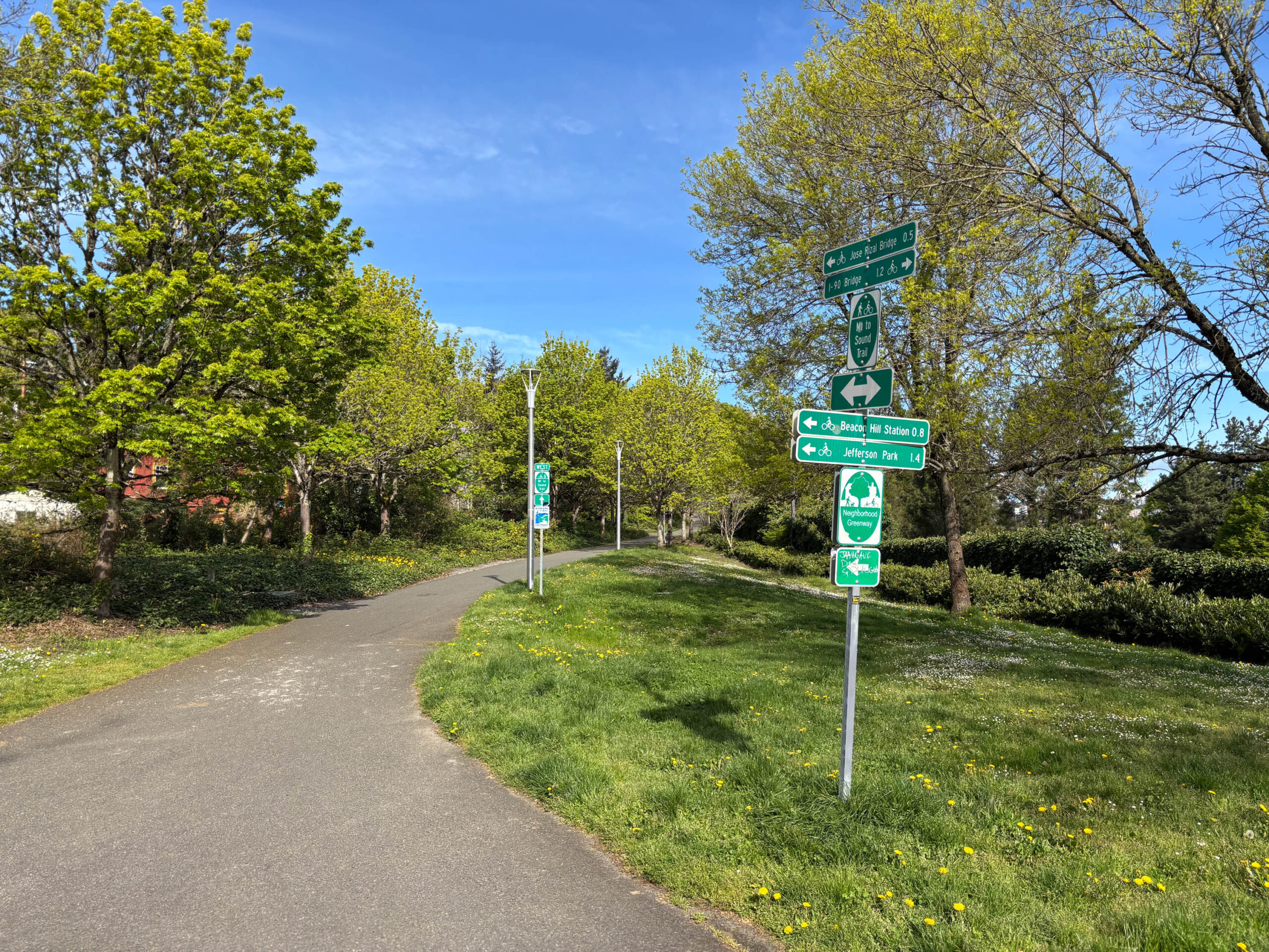
Looking at the map, you’d probably choose to head from there over the Dr. Jose Rizal (12th Avenue) Bridge. From Wisteria Park at 15th and South Main Street, it’s a short walk on Jackson Street to 12th. Then you aim south over the bridge, and make your choice of 12th, 14th, or 15th to get up near El Centro de la Raza. Beacon Avenue South will take you the rest of the way to Jefferson Park.
But the bridge didn’t exist yet for the Scouts on September 17, 1910. It was finished a year later, in 1911. My guess is that they walked along Rainier Avenue to 23rd, south to Spokane Street and then west to the park. That’s still a popular driving route.
My Beacon Hill route
My son and I took a different route. I decided to try to take as many trails, greenways, and walking paths as possible. I knew the bridge wasn’t historic, but also Rainier is inhospitable since it’s the only way for cars to get past I-90. So we looped east around I-90, briefly using the lid.
We headed east on Washington to Pratt Park. From there we entered the Central Park Trail. Seattle doesn’t have a Central Park, but it has a Central District. The Central Park Trail was created to link a series of Central District parks from Pratt Park, through Dr. Blanche Lavizzo Park, and along Judkins Park to the I-90 Trail.
Next we circled past the still-under-construction Judkins Park Station. The I-90 Trail is part of the Mountains to Sound Greenway, a partially complete bike route from Snoqualmie Pass to Puget Sound. It splits on both sides of the freeway here, so we started on the north side and then took the south side all the way to 18th Avenue South.
18th Avenue South is also known as Beacon Hill Healthy Street, and it is mostly closed to cars. The road has a gentle, gradual rise in grade making it a good bike route and easy walk. The Health Street zigs and zags, then turns on Hanford and finally enters Jefferson Park on Lafayette.

Along the way to Beacon Hill
Eventually we passed four skate parks, and this leg took us past our first and second in Judkins Park and Jefferson Park. Before that we stopped at the Franz bakery shop, which is stocked with lots of snacks for the nearby middle school. Other good choices for snacks are Seattle Fish Guys and Parnell Market, depending on your start time.
Up on Beacon Hill the healthy street keeps you in a residential neighborhood, but shops, cafes, and the library are only a block or two away.
Judkins Park, Jefferson Park and the Jefferson Community Center, and the Beacon Hill Library all have public restrooms.
Georgetown
The next stop on the hike is South Park. A glance at any current map will show that you need to get there through Georgetown, on Lucile Street.
But back in 1910 there were a few ways down the side of the hill: Lucile Street, like today; Dakota Street; or on old paths through the Maple Hill community.
I-5 construction later destroyed the connection at Dakota Street. But I ruled this out anyways. It was the least direct path for them, due west. That’s counter to the article’s statement of heading southwest to South Park. And I don’t know of anything in particular in the old town of South Seattle that would draw them down out of their way.
Maple Hill
Old real estate maps show aspirational roads on the west side of Beacon Hill that were never built. They include a fake direct connection on Snoqualmie from the south end of Jefferson Park. Those didn’t exist, but detailed 1930s aerial photos illustrate “goat trail” walking paths down the hill. They are in the rights of way and across unusable property in rugged terrain.
Now that area is I-5, Maple Wood Playfield, and Maple Wood Elementary School. But back in 1910 the area was a remnant of Maple Hill, which grew from Jacob and Samuel Maple’s 1851 settlement. To be clear, the concrete roads and sidewalks in the 1930s airplane photos were just a few years old and weren’t built yet in 1910. The area around Lucile and 12th was improved in the 1910s, but that was still after the Scout hike. So I think even Snoqualmie, Corson, and 12th were just dirt roads when the Scouts hiked here.
The Scouts could have walked on these goat paths. But there were lots of little left-over communities in Seattle, including right in the center of the city on the side of First Hill. So that wouldn’t be novel. That’s why I think we walked the same route they did, down Corson or 12th to Lucile.
It’s also worth mentioning that Georgetown only became part of Seattle five months before their trip, in April 1910.
My Georgetown route
From Jefferson Park we exited to the southwest, down through the Beacon Food Forest. Dakota Street led us to an extension of the Beacon Hill Healthy Street which is still under review. It takes Dakota, 14th, Nevada, 13th, and Snoqualmie. Then the Healthy Street takes the direct path on 12th Ave S, but we chose to stick with Corson Ave S to Dawson and watch big construction vehicles in Maple Wood Park.
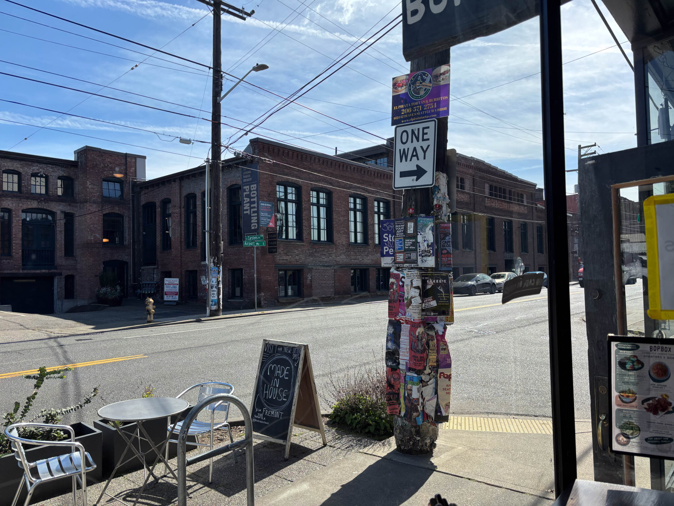
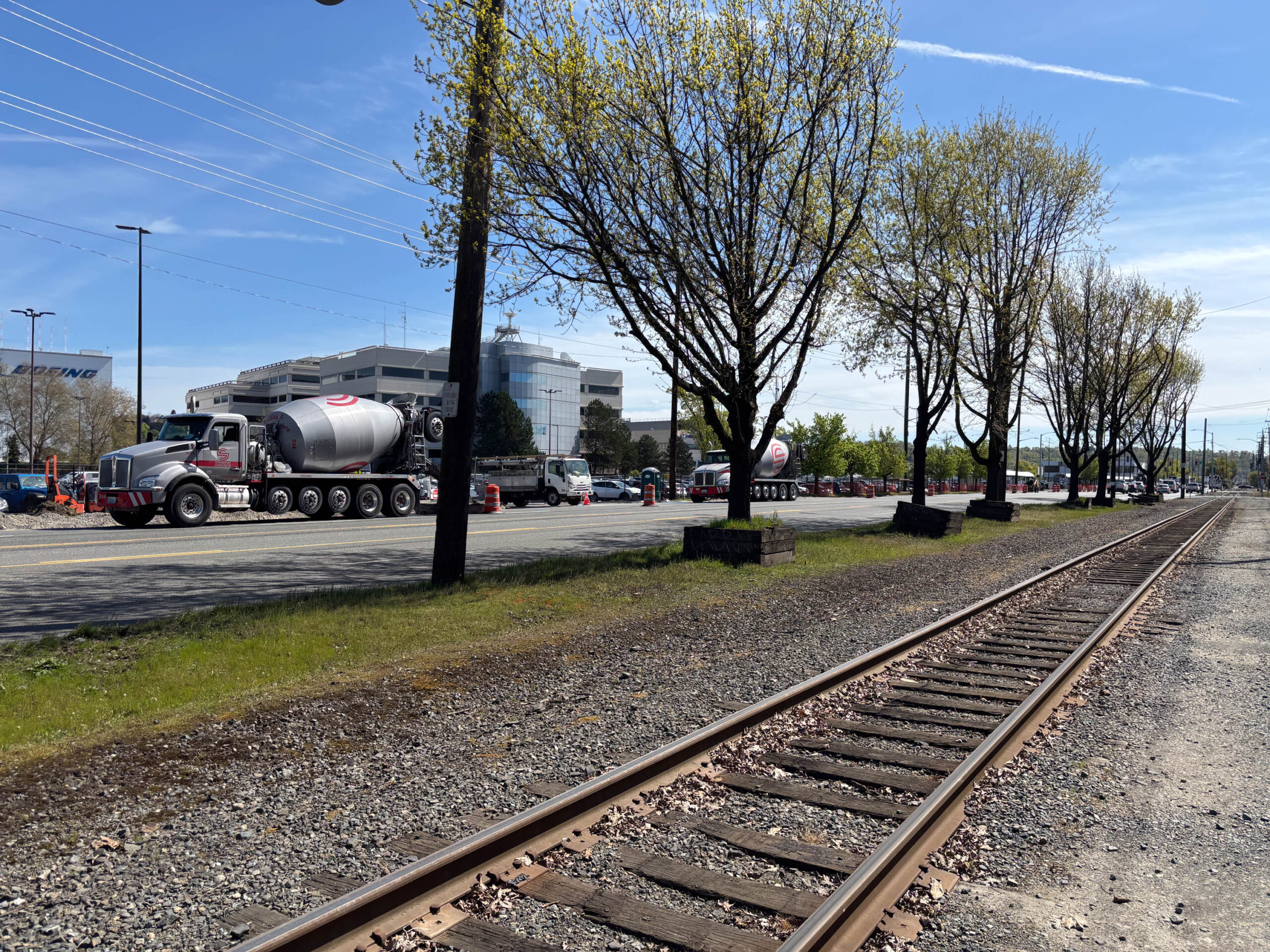
After going under I-5 and over the railroad tracks on Lucile Street, we were surrounded by cafes, ice cream and cookie shops, restaurants, and pubs on Airport Way, and we were ready for lunch. We ate Korean at BOPBOX and recharged. Many more restaurants dot the route toward South Park – Calozzis Cheesesteaks looked popular – and South Park itself has lots more lunch options too.
Secretly I had Georgetown pegged as a possible exit point if we were done for the day. The Metro 124 goes straight downtown from here. There are public restrooms at Maple Wood Playfield (when it reopens) and Georgetown Playfield.
South Park
Okay, so next they went “southwest to South Park”.
Today there is one bridge to get you there over the Duwamish River, the South Park Bridge. Back in 1910 it was a different bridge. It was also a different river. The Duwamish River was cut straight starting in 1913, making it easier for ships to navigate but drastically altering the environment.
The Scouts took Carleton South straight across the Duwamish River, then 8th Avenue South to the heart of South Park at Cloverdale Street.
My South Park route
We cut back from Airport to Corson after lunch, and followed that southwest across Michigan Street. Oxbow Park, with the old Hat and Boots gas station remnants, provided a nice cutover to quieter Carleton Avenue, the Scout’s likely route.
Eventually the Georgetown to South Park Connection project will provide a fantastic alternate route. Instead of taking Carleton, future hikers should continue east on Warsaw to Ellis, then take the mixed use path south from there. It will lead along East Marginal Way all the way to 16th Ave South and the South Park Bridge.
Our route was more adventurous than the Scout’s route or probably yours. Trail construction seemed to close the sidewalk on the north side of East Marginal (it was probably open), so we crossed to the south and walked on the railroad tracks. This brought us right next to an arm of the old Duwamish River channel next to Cedar Grove Composting, but it also took us right past the compost!
Across the bridge, we hooked along nearly finished South Park Plaza onto Dallas Avenue and then Thistle for a side trip. The church at 833 S. Thistle St was the meeting place of Troop 263 from about 1920. George Nakashima was in Troop 263 briefly (I have a long article about Nakashima) as well as Chet Sakura, Seattle’s first Asian American Eagle Scout, and his brother Chip.
From the church we turned south on Cloverdale to 8th and stopped briefly at South Park Library. I returned a CD I was carrying, and checked out a book to read on the ferry.
We passed River City Skatepark, the third and most elaborate on our trip. The public bathroom at South Park Community Center is closed during renovations, but there’s another at South Park Library.
Fauntleroy
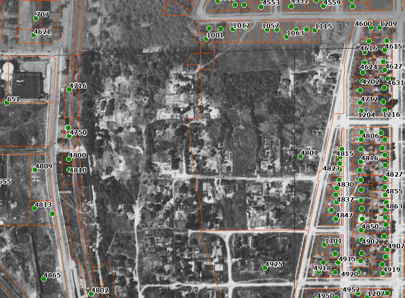
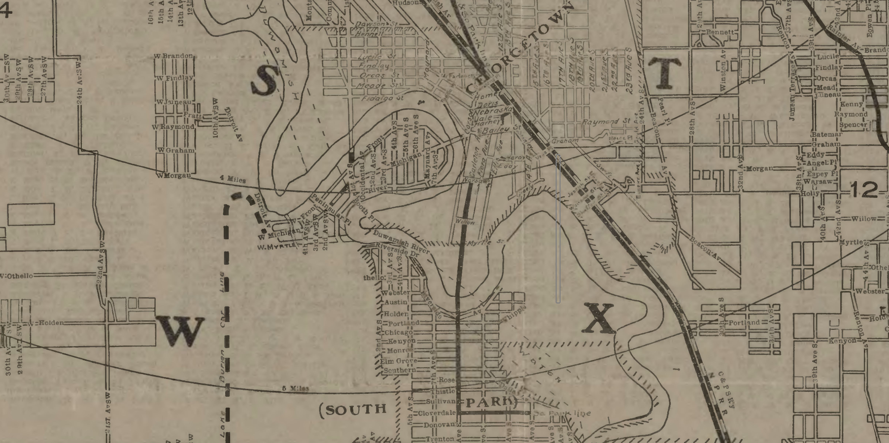
The Scout’s trip continued “thence due west through thicket and brush [to Fauntleroy Park] to the Sound and Fauntleroy Beach”. I’m not positive yet, but I believe in 1910 “Fauntleroy Park” referred to the beach area, not the upland park we have today.
The 1911 map at the top of this page shows essentially no settlement west of South Park to Fauntleroy. There were just two avoidable pockets west of 1st Avenue South. The 1912 Sanborn fire insurance map backs this up. Not all of the land was platted for sale, and many of the platted tracks had no homes on them at all. There were few houses around Fauntleroy dock despite the streetcar connection. Another thought is that the Scouts’ “thicket and brush” might indicate they cut through logged land.
My Fauntleroy route
I really dreaded the walk up Olson Place. It just didn’t look safe on Street View. We needed to gain 300 feet of altitude alongside fast cars in a dirt-covered shoulder that Google Maps refuses to use for pedestrian routing. Earlier a Metro 60 drove by, and my son asked if we could ride the bus instead of walking. I thought about it at the library, and couldn’t figure out the difference between sitting for 10 minutes at the library and sitting for 10 minutes on the bus.
So we caught the Metro 60 near 5th Ave S. After the Olson/Myers P&R, the 60 stops right at Olson and 3rd Ave SW, which must have limited ridership but was perfect for us.
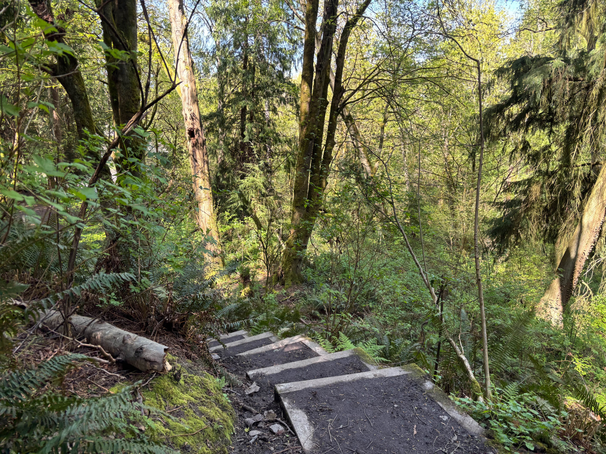
We walked through the isolated residential neighborhood on 3rd Ave SW to its end. Then we went around a barrier and entered Westcrest Park. This part of the park is stunning, a completely different environment than the rest of the trip with dense forest. I didn’t expect to see any of the wilderness they traversed, but I think we got a glimpse here.
Exiting Westcrest Park on Barton, we continued west to Roxhill Park. After a break we continued west to the Barton Street P-Patch. We cut south to Cambridge, then entered Fauntleroy Park just west of 37th Ave SW.
If Westcrest park gave us a glimpse of what Seattle used to be, Fauntleroy Park showed it clearly. We wasted time needlessly going up and down, crossing creeks multiple times, undulating through the woods and making sure not to turn the wrong direction. It was fantastic but got me in trouble at the end of a 13 mile hike.
Our trail exited into a parking lot next to the Fauntleroy YMCA, and we turned past the Fauntleroy Children’s Center and then onto SW Director St. This took us straight to Fauntleroy Way.
At Roxhill Park we passed our fourth skate park. There’s also a crossing with the Longfellow Creek Legacy Trail there.
Heading home
After arriving in Fauntleroy, they must have taken a street car or mosquito fleet steamer back to Seattle. Today that means the Rapid Ride C or Vashon ferries.
Since we made the trip on a weekday, we decided to go with the ferry option. (The water taxi doesn’t run on weekends.) We took the next Washington State ferry across to Vashon Island. There we waited a bit for the next King County Water Taxi (passenger ferry) around Alki to downtown Seattle.
From the Rapid Ride C on Alaskan Way, or from the ferry terminal you can walk to 1st and Jackson and take the First Hill Streetcar back to Wisteria Park if you left cars there. We instead followed new pedestrian bridges northeast, and took a Rapid Ride G back home.

Map of my route
Here’s a link to an All Trails map that you can use as a starting point for your adventure.
Planning tools
- I highly recommend Seattle’s public bathroom map, which shows which are opened and closed and includes hours of availability. Remember that other public venues like libraries are not included on this map.
- You can edit my AllTrails map if you’ve got an account
- I recommend OneBusAway in case you suddenly need to ride a bus, and also to determine the ferry schedules. I don’t ride Washington State Ferries or the Water Taxi regularly, and it was honestly confusing to read the schedules. When I arrived I found that there were unplanned extra sailings to Vashon. The fare signage on Vashon for the Water Taxi was out of date. Just ask someone if you’re unsure, that’s what I did.
- There are no signs in Fauntleroy Park. In addition to the trail apps, consider bringing a map like Fauntleroy Watershed’s trail map or self-guided nature walk.
More I wrote
My articles on early Seattle Scouting:
- Seattle’s first Scout hike
- Seattle’s first patrol leaders
- Start of Scouting in Seattle
- Elmer Katayama at Camp Parson’s opening
- George Nakashima and Scouting
- Aldus Hoopman, Seattle’s first Eagle Scout
- Troop 50 to 59
My articles on early Seattle Cub Scouting:
- Cub Scouts began in Port Angeles (part 1)
- Camp DYB, 1925 Cub camp in Port Angeles (part 2)
- Wolf Cubs lost at war (part 3)
- Blue Ox Camp, Seattle’s Paul Bunyan themed camp (part 4)
- What did they sing at Blue Ox Camp? (part 5)
- Cub Scout Alphabet
More walks:
- Aoi Bridge and Tamagawa Aqueduct walk
- Walking off into the Sunset: a history hike of landmarks in Seattle’s Capitol Hill neighborhood reviewing the book Seattle Walks (Capitol Hill Seattle Blog)
- Photos on walks in Tokyo from 2000-2008. In particular I’ll highlight Streetcar Memories, describing the route of the number 38 Jyoto-sen toden streetcar; Walk to Work 4, from Higashi-Koenji to Shinjuku; and Urban River Cycling, from Mitaka to Akasaka-Mitsuke.
Discover more from ba-kground
Subscribe to get the latest posts sent to your email.